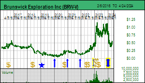
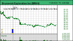
Brunswick Exploration Inc finally published an update for its Mirage project on December 5, 2023, and, not surprisingly, the market decided it was not good enough. It did not help that the spot price of lithium carbonate dropped below $8.00/lb, and that the hedge fund short attack against lithium producers has helped lithium producers drop to their lowest price in a year. Brunswick last provided an update on October 3 when it reported that it had completed 15 holes at Mirage of which 12 intersected spodumene bearing pegmatite intervals up to 52 metres. The company provided no information about drill hole locations nor what additional prospecting had turned up within the 5 km by 20 km northeast trending Mirage property. What the market wanted was a sense of the scale of the Mirage potential, especially in light of the 3 km by 500 m wide field of spodumene boulders as big as 6 metres identified down ice from a 2.7 km corridor of outcrops to the northeast. The update provided this week, however, was confined to a 2 km by 1 km area where the company has completed 36 core holes totaling 5,080 metres. These are shallow holes to a maximum vertical depth of 150 metres. A winterized camp has been established and Brunswick plans to return by mid January to conduct a 15,000 m program during Q1 of 2024.
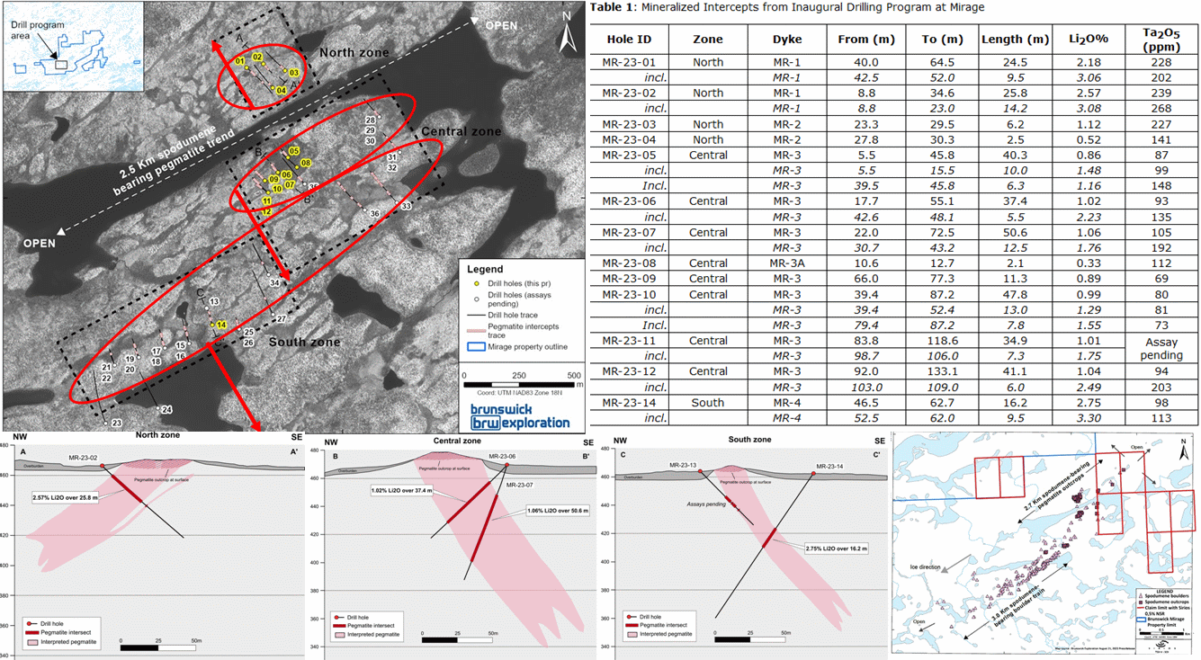
Assays published for 14 holes indicate that Mirage has three northeast trending dyke sets which the company has labeled the North, Central and South zones (the North zone appears to have 2 dykes). The drilling strategy seems to have involved starting the initial hole under the three main outcrops in this 2 km by 1 km area. Brunswick has published a drill plan outlining the drill hole traces and highlighting spodumene pegmatite intervals. All but 3 holes intersected spodumene bearing pegmatite. It is disappointing that the company decided not to publish azimuth, angle and total hole length information, even for the assayed holes, supposedly because they are afraid potential predators might figure out what Brunswick has at Mirage. The company provided one section for each zone.
Of the first 14 holes all but #13 intersected spodumene bearing pegmatite (the first hole drilled in the South Zone was drilled in the wrong direction but map have nipped some pegmatite and assays are still pending- hole #14 intersected 16.2 m of 2.75% Li2O. Only about 100 m strike of the North Zone was tested with holes 1-4 of which #1 and #2 delivered 24.5 m at 2.18% and 25.8 m of 2.57%, with grades spiking to 3.08%. True width is estimated at 90%. The MR-1 dyke dips to the northwest. Holes 3 and 4 intersected a narrower dyke to the southeast which they call the MR-2 dyke.
Holes 5-12 were drilled along a 300 m segment of the MR-3 dyke and yielded intervals up to 50.6 m grading 1%-2%. MR-3 also strikes northeast but dips to the southeast. Toward the end of the program Brunswick stepped about 500 m northeast close to the boundary of the inlier claims optioned 75% from Osisko Development Corp and drilled holes #28-30 from what appears to be a single drill pad. The map shows spodumene was intersected where you might expect the MR-3 dyke to be, giving it a strike of 750 metres. Hole 35 returned to the main part of MR-3, but the surface projection of the spodumene interval suggests a separate parallel dyke has been intersected.
Assays were reported only for #14 of holes #13-27 drilled into the South Zone which call the MR-4 dyke. This hole yielded 16.2 m of 2.75% Li2O. The MR-4 dyke has been encountered along a strike of 750 m and dips southeast at 45 degrees. Brunswick makes the important statement that similar bonanza grade mineralization has been seen in all the MR-4 dyke holes.
After hole #27 they drilled the #28-30 holes stepping out northeast of the MR-3 dyke for which assays were reported, and then stepped back to the southeast to drill holes 31-32 which intersected spodumene of what looks like a separate dyke that lines up with the dyke encountered by hole #35. But things got really interesting with hole 33 and 36 which have a much greater extent of surface projected spodumene intervals than any of the other 34 holes. They have included these holes in the Central zone, but, thanks to hole #34 which intersected spodumene half way between #33 and the southwestern limit of the South Zone, it looks like #33 and #36 are the continuation of the 2%-3% grading MR-4 dyke.
What does this mean? Is it a Peanut or a PMET? The company states that it has intersected a combined strike length of 1,500 metres, but if you connect some dots it is at least 2,000 m. Just to get a sense of the scale, one can imagine 2,000 m strike by 25 m thickness by 300 m down-dip and 2.6 specific gravity. That gives you a tonnage footprint of 39 million tonnes. That is a lot more than a Peanut, but it also is not close to being a PMET whose CV5 zone yielded 109 million tonnes of 1.42% Li2O based on 163 drill holes representing 56,000 m. Brunswick has only drilled 36 holes for 5,080 metres. The market saw the small area footprint, realized that the 15,000 m program in Q1 of 2024 would be focused on delineating the dyke sets within this area, and while the average grade might prove better than CV5, the tonnage would remain below 50 million tonnes, which the market thinks is Mickey Mouse. In an earlier KW episode I had joked that when Brunswick reveals what it has at Mirage Gina Rinehart would come and eat up Brunswick. But in the KRO Slack Forum we ended up joking that in light of this update Gina would just send her cat to take care of Mickey Mouse.
But one thing puzzled me, namely this statement by Bob Wares: "I believe the distribution of the first four mineralized dikes at Mirage does not explain the three-kilometre-long trend of rich spodumene-bearing boulders that occurs to the southwest. With more outcropping spodumene-bearing dikes located another three kilometres to the northeast, we have considerable exploration work and drilling to do to unlock the full potential of this promising property."
I asked Bob on what basis he made that statement and he explained that the MR 1-4 dykes have high levels of tourmaline and low levels of muscovite, whereas the boulder field that stretches 3 km to the southwest has lots of muscovite and almost no tourmaline. He also pointed out that the abundance and size range of the spodumene crystals in the boulders is very similar to what they are seeing in the core of the MR1 and MR-4 dykes which is running 2%-3%. The difference between the mineralogy of the boulders and the bedrock hosted pegmatites makes it impossible for the MR 1-4 dykes to have been the bedrock source. I then queried him on why he was looking for more potential 3 km to the northeast where apparently they have outcrops? The company's boulder distribution map shows that boots on the ground found the boulders largely concentrated in what appear to be two linear trends within the 3,000 m by 500 m corridor that has the same orientation as the ice direction.
The important news in the Mirage update is that the MR 1-4 dykes have a northeast orientation which happens to be the same as the ice direction. Because the boulder train had the same orientation everybody assumed glacial transport dropped them where they ended up and that the roundedness was due to abrasion as the ice sheet entrains loose boulders and drags them along the bedrock. If the boulder gets into the ice sheet it can be transported hundreds of kilometers. When the ice sheet stops flowing and melts, these boulders called glacial erratics end up sitting on bedrock with completely unrelated geology. AntarcticGlaciers.org has a good publication on Glacial Erratics.
The problem with the ice sheet transport explanation is that the Mirage boulder collection is too uniform and concentrated to have been plucked from bedrock and dragged 5-10 km from their location. I asked Bob if there is any outcrop in the vicinity of the boulders and his response was that this area is completely covered by overburden in which these boulders sit. So the lack of outcropping pegmatite doesn't mean there is no pegmatite in this area. I suggested maybe these boulders are sitting on top of a big pegmatite, one with Greenbushes scale. This pegmatite may have been a ridge which over time got broken up through fractures and then underwent "chemical" weathering courtesy of the freeze-thaw cycle in the James Bay region which would cause the boulders to end up somewhat rounded without ever having been tumbled as happens in shoreline or river systems, or from extensive dragging when stuck in the base of an ice sheet. For an idea of how this in situ weathering happens, check out this Formation of Rounded Boulders Video which one my KRO Slack Forum members tracked down while we were having a discussion about the origin of the Mirage boulder field.
Bob Wares did concede that this was a possibility, and that a glacial expert on their team has suggested the displacement is less than 500 m. He does not like the idea of drilling a fence of scout holes to prospect the bedrock and hope to spear a blind pegmatite, especially given that a key talking point during the past two years has been that Brunswick is only chasing after outcropping pegmatites. But in light of the bonanza grades in the North and South Zone dykes, the similar spodumene crystal distribution within the boulders, the mineralogical difference of the boulders, and the scale of the boulder field, lining up with what appears to be an important structural trend suitable for pegmatite emplacement, it is plausible that the boulder field is sitting on top of its bedrock source. In 2012 when Talison Lithium Ltd owned Greenbushes it reported a resource estimate of 118.4 million tonnes of 2.4% Li2O within a pegmatite body roughly 2,000 m long, 250 m wide and at least 500 m deep. Over the next week or so the company will decide if it will include some boulder field scout holes with the 15,000 m winter program. If neither "Mickey Mouse" nor anything up ice plausibly explains the boulder field, perhaps it is sitting on top of a Green Giant. As it now stands, the market thinks all that will change over the next 6 months is that a resource estimate will emerge for the small North-Central-South area, and that for an outcome of this size the Mirage play is already fully priced. Hopefully they decide to test the Greenbushes in situ hypothesis this winter. |